To be privately owned
CastleThorr
Thorr Castle
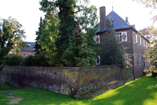
Haus Thorr is one of the smaller country estates on the Erft river. The manor house belongs to the district of the same name in the city of Bergheim in the Rhein-Erft-Kreis.
The castle and the village, which derives its name from the castle, are located at the Erft crossing of the important Roman road, still clearly visible here in a straight line, from Cologne (Colonia Claudia Ara Agrippinensium) to Tongeren, the ancient Aduatuca Tungrorum, which is now called Via Belgica. The current road, Bundesstraße 55, bypasses the village due to the lignite mining in the central part of the Rhenish Lignite Mining Area. It crosses here the Roman district road from Zülpich (Tolbiacum) to Neuss (Novaesium), today Bundesstraße 477. In addition, the road accompanying the Erft from Lechenich also joins here. Today, beyond the Erft, the Erft cycle path runs. The Bergheimer Acht circular cycle path, with its southern loop, passes four castles. One of the sections of the Water Castle Route is also designated here.
The name Thorr suggests deriving it from a Roman fortification tower, "turris". The place is first mentioned as Ture in 997 (doubtfully also Witten-Düren possible, see Thorr), a bridge Thurre over the river Arnefe in 1051, and a knight Rudolf von Turre in 1140. The respective lords of the castle were enfeoffed by the Counts of Jülich. A Gisilbrecht von Thurre was Vogt in Bergheim in 1335. The castle was one of a total of 238 Jülich knight's seats. In 1506, the property came into the possession of the family then residing at Burg Drove through the marriage of Fritza von Thorre with Bernhard von Weworden, called Bulver. The next change through marriage can be seen from the alliance coat of arms above the entrance portal of the manor house: Bernhard Kox, Drossard of the Freybaner lordship of Merode, married the heiress Sybilla Catharina von Weworden, called Droff. The new manor house was built by both in 1680. A painting from 1723 shows the courtyard still as a regular, three-winged complex with three towers. In 1796, at the beginning of the French period, the property came into civilian hands; Johann Anton Türk became lord of the castle. One of his descendants had it renovated and partly rebuilt again in 1860. The date is in the iron grating of the fixed bridge.
Architectural Description+
The two-story, simple manor house from 1680, standing at right angles to the street, a brick building with six axes and a hip roof with small dormer windows and two weather vanes mounted at the ridge ends, is significant. The portal made of ashlar with a triangular gable and the coat of arms is decorative. The holes for the chain of the former drawbridge are still visible. The elongated east wing of the outer bailey, running parallel to the street, was renewed in 1884. The second wing no longer exists. The moats are now dry.
Take Mobile History with you
You are reading this text for free. Premium adds what matters on the road: descriptions read aloud, sites found through your camera, whole regions taken offline.
- Every description, including the ~17,700 Premium sites
- Audio guide: have descriptions read to you on location
- AR finder: see sites through your camera, with distance and bearing
- Unlimited saved sites
14 days free, then from €2.99 a month. Cancel anytime.
Source: Wikipedia · Licence: CC BY-SA 4.0
This description draws on the facts documented in the linked Wikipedia article; Wikipedia content is licensed under CC BY-SA 4.0. Wording and editing: Mobile History.
Location: 50.9377, 6.6274