Museum
CastleSulzbach-Rosenberg
Sulzbach Castle
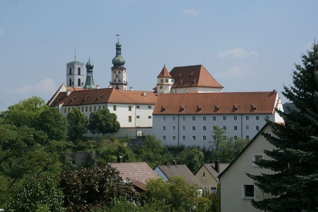
Sulzbach Castle was located in the area of today's Upper and Lower Sulzbach Castle and the St. Hedwig's Convent there, as well as the oldest core of the old town of Sulzbach-Rosenberg in the Upper Palatinate (Amberg-Sulzbach district).
The castle and settlement are situated in an area that has been very dynamic in terms of dominion and settlement history since the late Merovingian and early Carolingian periods, its importance for the monarchy and the noble families associated with it arising from a number of different factors. Sulzbach apparently benefited from its extremely favorable traffic-topographical location, a so-called traffic gateway situation. Crossing the Alb was relatively easy at this point. The town and the castle thus developed at one of the most important traffic routes and hubs in Northeast Bavaria: important north-south connections on the Würzburg/Erfurt – Bamberg – Forchheim – Nabburg/Premberg – Regensburg axis, as well as one of the most important long-distance roads to Bohemia, touched the Sulzbach area. Its geostrategic location at the gateway to the Bohemian sphere of influence is likely to have been particularly favorable for the castle's development into an important center of power during the 9th to 12th centuries.
History of Dominion
From the late Merovingian period onwards, the area around the middle (Upper Palatinate) Vils and Naab rivers increasingly came into the focus of various power factors. Their representatives presumably did not solely follow colonialist principles in the sense of 'agrarian land development', but also pursued economic-political and military interests, insofar as these could even be separated from each other. Thus, from the late 7th and early 8th centuries, ducal-Agilolfing power aspirations met Frankish-Carolingian claims in this region, to which a third power factor was added by the formation of empires in Bohemia and Moravia. The reason for these efforts of dominion was probably the geostrategic and traffic-topographical location of the region, but presumably also its rich mineral resources. In the Sulzbach area, these were primarily the high-quality iron ores, which formed the economic backbone of the region until the 20th century.
It is conceivable that as early as around 700, fortifications were erected by Frankish and Bavarian sides to enforce and secure political and economic goals. However, the archaeological source material is too sparse for precise statements on the oldest layer of medieval castles in this area, which should not serve as negative proof for the late Merovingian and early Carolingian periods. The oldest burials in the Lauterhofen cemetery adjacent to Sulzbach around 650/680 AD, the mention of Lauterhofen in the Divisio Regnorum of 806, and the continuity of rule at this site until the 12th century already reflect the basic features of royal and dynastic engagement in the northeastern Nordgau.
In a similar form, this can now also be assumed for Sulzbach Castle and its surroundings. The idea that the area west of the Naab belonged to a region of land development, whose settlement and integration into forms of dominion only began in the course of the late 9th or even the 10th century, must today be largely revised or viewed in a more differentiated way. From the time of Charles Martel, increasing Frankish influence can be expected as far as the area around the middle Naab. Indirect written evidence for this, despite the desolate written source situation, can be found in the missionary efforts of Anglo-Saxon monks ad Nordfilusa (on the northern Vils) around 742, pushed by the Bavarian side. After the deposition of Tassilo III by Charlemagne, the importance of the Vils-Naab area is again clearly evident through the special status of the royal court of Lauterhofen from 806 and the mention of Premberg in the Diedenhofen Capitulary. Even during the 10th to early 11th centuries, the area retained its imperial political dimension. In the Carolingian period, the historical foundations for the rise of important noble families such as the Bavarian Luitpoldings of the early 10th century, the Schweinfurts in Ottonian times, and the Diepoldings and Sulzbach counts of the 11th and 12th centuries were laid in the Nordgau.
Topography of the Castle Complex
Sulzbach Castle was located on the eastern edge of the Franconian Alb on an elongated terrace spur and was divided into a main castle of approx. 1.5 ha and a probable outer bailey of approx. 3 ha, whose oldest fortification was archaeologically investigated for the first time in 2008. The relatively good soil qualities in the so-called Amberg-Sulzbach Chalk Bay, especially in the Rosenbach valley, and the abundance of water with numerous karst springs at the foot of the castle hill offered comparatively good natural settlement conditions during the early Middle Ages. The location of the core castle in a river bend about 20 to 30 m above the Rosenbach valley and its large area correspond to the known topography of numerous early medieval castles in the Bavarian region. Today, the castle of the Palatine Counts of Neuburg-Sulzbach, predominantly built in its present form from 1582, stands on the main castle area, along with the Salesian Sisters' Convent of St. Hedwig, founded during the second half of the 18th century.
Research History
Until the beginning of archaeological measures, nothing concrete was known about the origins of the castle and settlement. The complex is not mentioned in any known written source from the 8th to 13th centuries. The earliest mention of a castle in Sulzbach dates only from 1329. According to local legend, the castle was built in the first half of the 11th century on the site of a predecessor stone structure, which has repeatedly given rise to speculation about the age and importance of the castle in local research history since the 16th century. It was undisputed, however, that the ancestral castle of the Counts of Sulzbach stood on the terrace spur, whose importance for the imperial history of the late 11th and first half of the 12th centuries has only become evident through recent historical research. However, the archaeological findings now prove that the castle was built about 300 years before its legendary foundation.
Archaeology of Sulzbach Castle+
The excavations from 1992 to 2001 in Sulzbach Castle yielded findings of a complexity previously unique in Southern Germany regarding the development of an apparently highly significant castle complex from the 8th to 14th centuries. These archaeological excavations were supplemented by investigations in 2008 and 2009, which for the first time provided insights into the early fortification of the castle settlement.
Prehistoric Settlement Traces
The earliest traces of human settlement on the castle hill can be dated to the Late Hallstatt or Early La Tène period based on numerous ceramic remains. A single find of a possibly Urnfield period rim sherd could indicate occupation of the site during the HaA/B stages; however, this find is not sufficient to prove an Urnfield period hilltop settlement on the ridge.
Settlement Period I (8th to early 9th century)
Medieval settlement on the castle hill begins with Settlement Period I during the 8th to early 9th century. A few finds may even indicate the beginning of settlement or at least a scattering of human settlement activity in the immediate vicinity of the hill around 700 or in the late 7th century. This would prove late Merovingian settlement activity in the central Upper Palatinate for Sulzbach, alongside Lauterhofen (Neumarkt district) and the Heuchling site (Nürnberger Land district). This is likely related to the aforementioned efforts of Agilolfing or – in the case of Sulzbach – rather Frankish rulers to incorporate the area into their sphere of influence. Traces of a post-built structure, probably over 16 m long, of unknown ground plan (hall?) in the southern half of the Upper Castle Courtyard belong to this early settlement period. Possibly, the newly created complex was protected at this time by a timber-earth fortification, which, however, could not be clearly proven. In 2008, the massive outer bailey fortification of the castle settlement south of the Christuskirche in "Neustadt" street was recorded for the first time. The impressive mortar wall found here apparently belongs to Settlement Period I. The castle settlement was additionally protected at this point by three staggered section ditches, and on the eastern slope by at least two slope ditches, which were archaeologically recorded in 2009.
Settlement Period II (9th to early 10th century)
At the latest during Settlement Period II, the castle came into the hands of an influential family who, judging by the quality of the structural and material remains, belonged to the Carolingian imperial aristocracy. The lords of the castle had a number of buildings constructed, some of which were made of stone, which underlines the importance of the complex. A comparatively small stone hall, which served as a representative building for the official business of the lordship, can be assigned to this construction phase. The building was erected on a wide slope terrace on the north slope and had a lower basement floor, which was probably accessed via an extension (Söller?). A large, stone-framed fireplace was located centrally within the lowest building level. As several window glass fragments prove, including a fragment with painting and lettering, the hall building was partly equipped with glass windows. Immediately south of the hall building, another building or an extension of unknown size was built. This part of the building was equipped with a channel heating system installed below the floor, which also speaks for a high standard of living culture in the Carolingian castle. Northeast of the hall building, another house was built on a rock terrace during the late Carolingian period. This was constructed as a timber-framed building and had a floor mortared with stone slabs, which was preserved over a large area. The church of the castle in the access area to the core castle also belongs to the buildings of Settlement Period II. The simple hall building with a relatively strongly recessed, semicircular apse in the east stood exactly in the center of the main castle. Early window glasses prove stained glass in this church at the latest during the 12th century. The Carolingian church hall has largely been preserved in the rising masonry of the chapel building to this day. From the 9th century onwards, a small noble cemetery adjoined the castle church to the north, from which a total of four adult and five children's graves were found, as well as displaced human bones without grave context. The adults were buried in walled stone cists. The oldest grave with the remains of a man over 70 years old was laid out during the 9th century. In the stratigraphically youngest adult grave, dated to between approx. 900 and the end of the 10th century, lay an equally senile woman. In contrast, at least two of the children's graves seem to have been laid out only in the first half of the 11th century. Apparently, at this time, the proximity of the adult graves of the 9th and 10th centuries was sought for the early deceased infants. This is associated with some interesting considerations regarding the history of dominion. The oldest grave of the 9th century was probably covered with a grave monument in the 10th century, which shows a memoria on site during the Ottonian period. The church can be clearly identified as a proprietary church of the nobility due to its associated 'family burial place' and almost certainly fulfilled an important function in the pastoral care of the surrounding area. This finding leads to a discussion of the forms of early church organization in the Sulzbach area, whereby the importance of the royal or noble proprietary church system in the Nordgau of the 9th to 11th centuries becomes clear.
Settlement Period III (10th century)
In Settlement Period III, two new stone buildings were erected as residential houses in the core castle. They stood south of the older hall building and west of the timber-framed building, with a small distance between them. Thus, an ensemble of four closely packed buildings was created, without them having a direct connection to each other. At least one of the new buildings was equipped with an underfloor heating system. During the late 9th/10th century, a workshop on the southwestern edge of the core castle processed various metals, including copper, copper alloys (bronze, brass), iron, and zinc. The production of rings for chainmail is certainly documented, perhaps also the manufacture of signet rings. At the latest during Settlement Period III, but probably already in Settlement Period II, the castle was surrounded by a mortared stone wall about 2.2 m wide. This probably completely enclosed the northern part of the present castle and at least also sealed off the southeastern part of the core castle from the outer bailey (today's town side in the area of the monastery). Access to the main castle was provided by a pincer gate about 18 m long, which ended at the height of the western end of the castle church. It was probably preceded by a sole ditch about 10 m wide already during the Early Middle Ages, which separated the main castle from the outer bailey. The existence of an early fortification wall in the west and southwest of the terrace spur cannot be proven, but cannot be ruled out.
The architectural structure of the castle in the 9th and 10th centuries clearly has its models in the palatial buildings of that time. In Sulzbach, the influence of early dynastic castle building by the palatial architecture of the Carolingian and Ottonian monarchy can thus be exemplarily observed. At the same time, the findings bear witness to the self-perception of the East Frankish nobility as largely independent and king-like representatives of secular power. The search for the lords of the castle in the 9th and 10th centuries among the documented Carolingian and Ottonian noble families of Bavaria must, due to the poor written sources, retain the character of well-founded hypotheses. A central figure in the considerations regarding the Carolingian castle and the oldest burial site of the 9th century is Count Ernst of Nordgau, who is considered the closest confidant of King Louis the German and one of the most influential representatives of the East Frankish high nobility of the late Carolingian period. In the sources, he appears, among other things, as the military leader of the East Frankish-Bavarian nobility in the conflicts with the Bohemians around the middle of the 9th century. Possibly, he was related to the Sulzbach and Schweinfurt counts, which, in addition to his imperial political importance, could explain the memoria proven on site. After his deposition in 861, he probably retired to his own estates, where he died in 865. From the second quarter of the 10th century, the castle could have been in the possession of the family of Count Berthold 'of Schweinfurt' of Nordgau, for which good arguments can be made. The extraordinary architectural features of the castle, its continuity as a seat of power from Carolingian to Salian times, its good geostrategic and geo-economic location point in this direction. In addition, there is an inner bond of the lords of the castle to the place itself, which is revealed by the burial site and the memoria cultivated at the castle, as well as probably close (familial?) relations of the 'Schweinfurts' to the Ernsten and the later Counts of Sulzbach. The archaeological situation at the castle further indicates that Sulzbach was directly involved in the conflict between Count Heinrich 'of Schweinfurt' of Nordgau and Henry II, as reported by Thietmar of Merseburg, in the summer of 1003. Without question, Sulzbach Castle can be attributed a central role in the power structure in the Nordgau during the late Carolingian and Ottonian periods.
Settlement Period IV (11th century)
At the beginning of Settlement Period IV, the representative hall building was partially destroyed, its high-quality floor – probably for symbolic reasons – was smashed. With the restoration of this building during the first third of the 11th century, the demolition of the two stone buildings of the 10th century in the courtyard took place. At the same time, the areas northeast of the hall building were leveled and the timber-framed building of Settlement Period II was abandoned. The restructuring measures in the residential area of the castle shortly after 1000 are probably connected with a change of ownership, which can be seen as a consequence of the events of 1003. Thereafter, there are indications that the central castle, important for the Nordgau county, came into the possession of the family of the later Counts of Sulzbach between 1003 and 1007. Thus, a counterweight to the power interests of the 'Schweinfurt' counts in their central territories in the Nordgau was to be created. The alienation of the Sulzbach castle, central to the self-understanding of the Nordgau counts, by Henry II may also have occurred to demonstrate royal authority on the one hand and to reward loyalty on the other. From the mid-11th century, the Counts of Sulzbach rose to become one of the most important noble families in the Empire and held a powerful political and manorial position in Bavaria far beyond the Nordgau. Their most influential representative, Berengar I († 1125), was instrumental in the overthrow of Emperor Henry IV and the installation of his son Henry V at the beginning of the 12th century. He can be considered one of the most dazzling noble personalities in the entourage of Henry V, who undertook a number of important political missions at court. The territorial basis of the family with numerous proprietary estates lay in the Nordgau with Sulzbach as its center. From here, they administered, among other things, the Vogtland of the Bishopric of Bamberg in the Nordgau, and from 1147 also the Regensburg Cathedral Vogtland. The high rank is also documented by the marriages of Berengar's numerous children. The family established close connections to the most important South German noble families of the early 12th century. Two of Berengar's daughters, Gertrud and Bertha, rose to royal status. Gertrud became the wife of King Conrad III around 1132, Bertha married the Byzantine imperial son Manuel I Komnenos around 1146 as a pawn of political powers and ascended the East Roman imperial throne shortly thereafter. With the death of Berengar's son Gebhard in 1188, the family died out in the male line.
During Settlement Periods IV (11th century) and V (around 1100 to approx. mid-12th century), the Counts of Sulzbach sustainably changed the building structure of the northern core castle. Not only written tradition, but also the building remains and the finds from this period give an impression of the high social and political rank of this family. As a replacement for the buildings demolished after 1000, two new residential houses were built in the area of the Upper Castle Courtyard, one of them certainly made of stone. Both were equipped with technically complex underfloor heating systems. In the course of the 11th century, the oldest stone wall of Settlement Period II/III in the north of the castle area was replaced by a new ring wall. The expansion of the sacred center was particularly important for the internal structure of the castle. A memorial chapel was erected over the graves of the 9th and 10th centuries, which structurally clearly referred to the oldest grave of the 9th century. At least two of the investigated children's graves were apparently only laid out in the early 11th century. The memoria for the castle lords of the late Carolingian period was apparently also maintained under the later Counts of Sulzbach. Further building and settlement remains from the 11th century prove extensive use of all investigated areas of the core castle.
Settlement Period V (around 1100 to approx. mid-12th century)
Settlement Period V archaeologically captures the heyday of the Sulzbach Counts. This phase initially saw the construction of an octagonal residential tower in the northeast of the castle, not far from the residential buildings. This shaped the appearance of the complex until its transformation into a palace in 1618. It is conceivable that the unusual ground plan of the tower for the late Salian period can be attributed to the close relations of the count's house with the Bishopric of Bamberg around or shortly after 1100. The St. Andrew's Chapel of the Bamberg Palatinate from the early Salian period is a possible model for the octagon, as its ground plan had almost exactly the same external dimensions as the Sulzbach tower. For a palace about 40 m long on the north slope, the hall building of Settlement Period II now had to make way. Like its predecessor, this building had a basement floor, which was possibly divided into two halls and was accessed from the courtyard via an extension. At the same time, one probably reached the higher rooms of the palace via a staircase accessible from two sides. Between the residential tower and the palace, a smaller residential house was built in place of one of the two heated residential buildings of Settlement Period IV, which could also be heated by a hypocaust air heating system and is called a Kemenate (lady's bower). In Settlement Period V, alterations were made within the memorial chapel. This probably included the preparation of an older burial chamber for the provisionally recorded burial of Berengar's wife, Countess Adelheid of Frontenhausen († around 1105). The findings of the 12th century also include two furnace systems and associated building structures, which indicate a craft use of the access area immediately in front of the pincer gate. Only hypothetical statements about the type of craft practiced there (metalworking, glass production, salt extraction?) are possible from the findings.
Settlement Period VI (late 12th to first half of 13th century)
The extinction of the Sulzbach line of counts in 1188 marks the beginning of Settlement Period VI. New castle lords, through the female line of the Sulzbachs, became the Counts of Grögling-Hirschberg. Although these also belonged to the representatives of the high nobility in Bavaria during the late 12th and 13th centuries, their center of power was in the Eichstätt area. However, the first mention of Sulzbach as a market (1253) and the first indirect mention of its own parish (1252) fall within the time of the Hirschberg counts. Settlement Period VI is primarily characterized by a renewed redesign of the northern core castle, which illustrates the loss of importance as the center of a widespread complex of possessions and the focal point of dynastic self-perception. The structural changes between 1188 and 1250 included the demolition of the early medieval ring wall in the access area to the core castle, which resulted in its significant reduction towards the outer bailey or town side. The underfloor heating system of the Kemenate (lady's bower) built in Settlement Period V was also abandoned, as was a wooden building south of the residential tower and an indescribable stone structure in the extreme southwest of the core castle. At the same time, the numerous finds and the remains of a tiled stove between the palace and the Kemenate indicate continued use during the first half of the 13th century.
Settlement Period VII (second half of 13th to end of 14th century)
Significant traces of construction activities at the castle can only be found again at the beginning of the most recent Settlement Period VII. This includes, as the earliest measure, the (re-?) construction of a massive fortification of the western and southwestern section of the main castle. A few decades later, around 1300, a large box-shaped building was erected on a narrow terrace in the southwestern core castle area, which was demolished in 1874. This construction measure was probably related to the establishment of a Viztum (vice-dominate) at the castle under the Wittelsbachs, who took over the complex after the extinction of the Counts of Hirschberg-Grögling in 1305. After a fire in the 14th century, the castle church was restored and received a new, Gothic polygonal choir, but otherwise remained largely unchanged in its substance. In the 14th century, the castle experienced a checkered history of ownership, which was also reflected in its architectural structure. Thus, the erection of a second representative building on the town side ('Hochbau') fell into the period of the takeover of the castle and town by Charles IV, who made Sulzbach the center of his possessions in Eastern Bavaria (1355). The castle now had a double palace complex, with the Romanesque palace in the north and the Gothic Hochbau in the south of the northern core castle facing each other in parallel alignment. The Gothic palace building still characterizes the appearance of Sulzbach's old town today. In the Upper Castle Courtyard, a bakehouse was built in the late 14th century, which is mentioned in written sources at the beginning of the 15th century and could be identified archaeologically by the remains of its baking ovens. Further wall remains in the gate area to the Upper Courtyard and in the access area between the outer bailey and the main castle indicate alterations to the gate situations during Settlement Period VII.
With the end of the 14th century, the archaeologically recorded medieval construction measures largely cease. Only at the Hofkasten (court granary) were reconstruction measures carried out, which can also be proven by archival records. However, the importance of the site as a seat of power extends beyond the year 1400. Sulzbach retained its importance for the Palatine and Bavarian lines of the Wittelsbachs during the 15th century, who alternately guided the fortunes of the town and its castle, before it came to the newly created Duchy of Neuburg in 1505. This date marks the beginning of the transition from the medieval castle to the modern palace and thus the continuation of dynastic traditions at this site, which experienced a further climax with the establishment of its own Palatine line of Sulzbach-Neuburg at the beginning of the 17th century.
Take Mobile History with you
You are reading this text for free. Premium adds what matters on the road: descriptions read aloud, sites found through your camera, whole regions taken offline.
- Every description, including the ~17,700 Premium sites
- Audio guide: have descriptions read to you on location
- AR finder: see sites through your camera, with distance and bearing
- Unlimited saved sites
14 days free, then from €2.99 a month. Cancel anytime.
Source: Wikipedia · Licence: CC BY-SA 4.0 · Image: http://commons.wikimedia.org/wiki/File:2010.08.22.123059_Burg_Sulzbach-Rosenberg.jpg
This description draws on the facts documented in the linked Wikipedia article; Wikipedia content is licensed under CC BY-SA 4.0. Wording and editing: Mobile History.
Location: 49.5052, 11.7361