To be privately owned
CastleRaabs an der Thaya
Raabs Castle
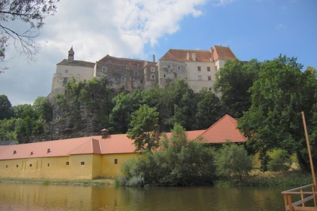
Raabs Castle is an elongated hilltop castle on a rocky ridge high above the town of Raabs an der Thaya, Austria, at the confluence of the German and Moravian Thaya rivers.
The medieval history of the Raabs area only begins with the castle complex discovered in 1992 by Kurt Bors in the Sand field (cadastral community of Oberpfaffendorf), about 2 km west of Raabs. According to dendrochronological data from the north wall, an area of 0.7 ha in the narrowest part of a Thaya loop was fortified and settled in the period after 926 to 929. This corresponds to the period from 907 to 955, when the Hungarians held supremacy in the formerly Bavarian Ostland, in present-day Lower Austria up to the Enns river.
Whoever initiated the construction of the "Sand" castle complex, which can also be described as a fortified settlement, the inhabitants were, according to the findings, Slavs. The lifespan of this early medieval complex was relatively short. After a few decades, it was already abandoned, following a clearly identifiable fire catastrophe, presumably caused by a hostile attack by Hungarian hordes. However, no written records of this early attempt at forming a dominion in the "Nordwald" have survived.
Written sources only begin with the mention of a castellan "Gotfridi admissus in castrum Racouz" in the chronicle of Cosmas of Prague in 1100. From the years 1074 and 1076, the mention of a forest area, the "silva Rogacz," in two royal donations to the Babenberg margraves, is known. Even today, Austria is called "Rakousko" by its northern neighbors, the Czechs – "the land behind Raabs."
The instability in the Bohemian-Moravian region in the first half of the 11th century repeatedly led to conflicts. For example, the Altaich Annals report for the year 1082 that the son of Margrave Adalbert conquered an "urbs" in the area of today's northern state border, after it had been violently taken from his father.
The chronicler Cosmas of Prague reports about Gottfried II of Raabs that he had taken in a Moravian Přemyslid, Lutold, who was apparently at odds with his relatives, in his castle, and that this guest then carried out nocturnal raids on Moravian territory, so that Duke Bratislaus of Bohemia finally felt compelled to march into Moravia with an army. However, before hostilities broke out, the Duke tried to resolve the situation peacefully by reminding Gottfried of earlier friendship alliances and demanding Lutold's surrender. The latter then occupied the castle with his men. At Gottfried's request, the Duke of Bohemia then besieged the castle for six weeks until Lutold surrendered and Gottfried was given Raabs Castle back. A Gottfried von Raabs is mentioned in 1113 as Burgrave of Nuremberg; he is said to have been appointed by Henry IV as early as 1104. Gottfried's brother Konrad I of Raabs already appears in 1140 in the retinue of Margrave Henry I.
Konrad II subsequently acquired the title of count. After the extinction of the Raabs counts in the male line (around 1192), the county was divided through the marriage of the two heiresses. The eldest daughter Sophie, through her marriage to Friedrich III of Zollern, became the "ancestress" of the Hohenzollerns and the later Prussian kings and German emperors. The western part with the castle went to the Counts of Hirschberg-Tollenstein, the remaining part with the market town of Raabs went to Duke Leopold VI around 1200.
In 1252, the undivided county came into the possession of the Counts of Plain-Hardegg through King Ottokar II. In 1260, the castle was owned by Wok of Rosenberg. In 1282, the Rosenbergs had to cede the castle to the Habsburgs, after a large part of the county had already been confiscated by King Rudolf in 1278. In the same year, the brothers Leuthold and Heinrich von Kuenring received the castle as a fief. Subsequently, the property was again separated: the princely part was pledged to Stephan von Maissau in 1283, while the western areas with the castle went to the Counts of Hirschberg. From 1297, the entire county with the castle was again a princely fief, and the eastern areas, castle, and market were now pledged to the Maissauer family.
In 1385, the property passed to the Lords of Puchheim, who, from the beginning of the 16th century, detached the dominion from the princely fiefdom and owned it as free property. Under them, the castle was largely expanded into the present-day "castle-palace." They obtained several market rights for Raabs and rendered great services at the court of the sovereign. During the Reformation, they were initially zealous adherents of Protestantism. Franz Anton von Puchheim sold the castle with all its appurtenances in 1702, after he had become Bishop of Wiener Neustadt, to Franz Anton von Quarient und Raall, under whom the Kollmitz dominion came to Raabs by purchase in 1708. In 1760, Baron Johann Christoph von Bartenstein bought the dominion and the castle. After his grandchildren, the property came by marriage to the Kaiserstein family and from them to Baron Ludwig von Villa-Secca. In 1878, Wilhelm Ritter von Lindheim acquired it, and from him in 1888, Imperial Count Philipp Boos von Waldeck und Montfort acquired the castle. In 1912, Baron Hugo Klinger von Klingerstorff became the owner. The First World War brought the economic collapse of the Raabs dominion, and the property and castle were auctioned in 1932. In 1970, Willy Enk became the owner of the castle, under whom extensive renovations were carried out. The current owner is the publisher Richard Pils.
Architectural Description/History+
Raabs Castle, still inhabited today, utilizes an elongated rocky spur on the southern right bank of the German Thaya, opposite the confluence of the Moravian Thaya flowing from north to south. Access to the spur, which mostly drops vertically, is only possible from the west, from the Oberndorf district. Due to the topography, an elongated castle complex was consequently built, approximately 200 m long with its outer outworks and a maximum of 40 m wide. Against the western access side, there are primarily corresponding outer bailey and zwinger systems; the actual, 107 m long, up to 37 m wide main castle is situated in a protected location at the eastern end of the spur. Due to construction activities over several centuries, an unusually strongly structured, multi-phase castle complex was ultimately created, taking strong consideration of the topographical conditions.
According to A. Klaar, the oldest parts of the building, the so-called "Feste Haus" (Strong House), and the Romanesque chapel dedicated to Saint Clement are only recognizable in their ground plan or currently as plastered structures.
At least in the lower areas, the wall structure of the access-side 5-sided keep shows strictly layered rubble masonry of partly unworked stones and remnants of joint pointing, which can be dated to the mid-12th century. From a height of approx. 10 m, the masonry recedes, and the keep forms a 7-sided ground plan, taking into account the wedge-shaped base, whose masonry is to be placed in the second half of the 13th century.
The construction of the castle chapel suggests an original two-story layout, as the basement, recently used as a wine cellar, is illuminated by a heavily altered primary round-arched window. In the chapel's south wall, a Romanesque funnel window was uncovered by the previous owner W. Enk at the height of the current western gallery, whose masonry, like that of the primary round-arched window in the apse, is structured by joint pointing and clearly dates the building to the 12th century.
On the southern enceinte, in a cellar east of the keep and in the plinth area of the chapel, exposed masonry from the first half of the 12th century can be seen in places. The strictly layered, hammer-dressed rubble masonry can be well dated to that period due to its small-scale nature, which is only zonally disturbed by inserted large ashlar blocks, and its still strongly tectonic layering. The plinth zone is often formed by "opus spicatum"-like structures.
According to the findings, the existence of an advanced, wedge-shaped keep-like tower, a component previously considered possible only in the 13th century, is already proven here for the 12th century. The early high standard of development of the castle is plausibly explained by its foundation as a local, representatively equipped center of power for the Counts of Raabs.
The Renaissance gate to the main castle also marks the location of the Romanesque gatehouse, which can be reconstructed as a strongly recessed flank gate near the tower. The original corner situation of the 12th century is still visible on the gate wall, whose recently exposed masonry with joint pointing shows similar structures to those at the base of the keep and the already described building findings of the 12th century. The neatly executed corner bond is partly formed by upright orthostats.
Prompted by individual finds unearthed during "treasure digs" by the previous owner W. Enk in the approximately 6 x 12 m cellar beneath the so-called "Great Knights' Hall," archaeological excavations (1995, 1999, and 2001) were initiated in this area. The results of the excavation conducted by S. Felgenhauer-Schmiedt are now as follows: A dry-laid inner wall is placed against a 1.12 m thick rubble stone wall with mortar binding running from west to east. To the west, the mortar wall forms a beveled end, presumably the continuation of the wall towards the southwest. To the east, a corner situation is still visible within the cellar. The younger enceinte, dating from the 14th century, is placed directly against the south front of this wall. Inside, numerous occupation horizons, mostly of screed and wooden planks, run against the older mortar wall. According to the finds and findings, an 11th-century settlement can be inferred on the Raabs castle hill. The discovered structural remains prove an early stone building, which is to be expected in other areas of the present castle, and stratigraphically dates to around 1050.
The numerous and complex findings from the first half of the 12th century allow for the reconstruction of an already highly structured and advanced castle complex – consistent with its first mention around 1100 – which integrated and enclosed the older 11th-century structures within a continuous enceinte in the early 12th century.
The "Feste Haus" (Strong House), a building component previously considered among the oldest in the literature, must, according to the latest findings, be placed in the 13th century. Massive alterations and extensions in the Late Middle Ages and the Renaissance ultimately formed today's multi-part "castle-palace," whose multi-story, peripheral wings surround two courtyards and integrate the aforementioned older building components.
The castle is strongly characterized by the unifying construction of the 16th century, as well as by the abundance of period-specific architectural details and, above all, by younger alterations from the 17th century.
The "Ochsenturm" (Ox Tower), belonging to the late Gothic expansion and projecting from the southern enceinte, is a semicircular battery tower with a diameter of 17 m. On the north front is the Renaissance-era well house, whose well shaft extends to the valley floor. The structures located to the west have the so-called "Hungerturm" (Hunger Tower) and another round tower in the outer bailey area as their late medieval core, but these are heavily reshaped by alterations from the 16th and 17th centuries. The "Hungerturm," together with another round tower demolished in the 18th century, formed a gate system that was located in front of the main castle gate.
Of particular note is the first forecourt below the "Tournament Garden," known as the "Umkehr" (Turnaround), with open arcades on the valley side from the Renaissance. The neck ditch between the outer bailey and the main castle is spanned by a modern stone bridge. The 16th-century zwinger wall, partly built into the steep slope, with semicircular shell turrets, encloses the flanks of the neck ditch and parts of the main castle. Recent building investigations initiated by R. Kuttig, based on corresponding findings, allow for the reconstruction of a massive 13th-century building above the "Umkehr" area. The platform referred to as "Bastei" (Bastion) is separated from the hinterland by a neck ditch carved out of the rock and connected to the grounds of the former "Schlossgärtnerei" (Castle Nursery) by an aqueduct-like arch structure. Presumably, the "Burggrafenburg" (Burgrave's Castle) was located in this area, in front of the main castle, built here after the dominion was taken over by the sovereign. On the 13th-century foundations, an outwork was built at the latest during the 16th-century fortification, which is also visible on the engraving by G. M. Vischer (1672).
Take Mobile History with you
You are reading this text for free. Premium adds what matters on the road: descriptions read aloud, sites found through your camera, whole regions taken offline.
- Every description, including the ~17,700 Premium sites
- Audio guide: have descriptions read to you on location
- AR finder: see sites through your camera, with distance and bearing
- Unlimited saved sites
14 days free, then from €2.99 a month. Cancel anytime.
Source: Wikipedia · Licence: CC BY-SA 4.0 · Image: Maciek Wegrzyn
This description draws on the facts documented in the linked Wikipedia article; Wikipedia content is licensed under CC BY-SA 4.0. Wording and editing: Mobile History.
Location: 48.8470, 15.4901