To be privately owned
CastleMosbach-Lohrbach
Lohrbach Castle
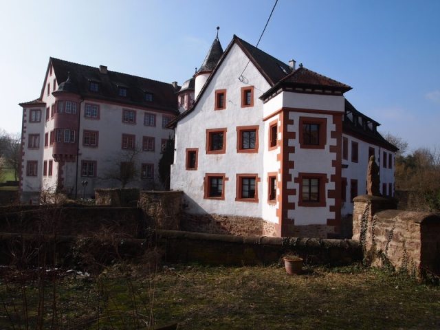
Lohrbach Castle is a 10th-century moated castle in the Lohrbach district of Mosbach in the Neckar-Odenwald district of Baden-Württemberg.
The castle allegedly came into the possession of the Counts of Lauffen in the year 1000, who received it as a fief from the Emperor. After the extinction of the Lauffen family, the complex passed to their heirs, the Lords of Dürn, and from them, through further inheritance, to the Lords of Limpurg in 1251. In 1277, a Ulrich von Lorbach is mentioned for the first time, a younger son of Walter II von Limpurg, who was named after his seat in Lohrbach and joined the Order of St. John, bringing the castle into the possession of the order around 1291. In 1299, the order complained about the destruction of the castle by Eberhard I of Württemberg. The Order of St. John then sold the castle to Konrad von Limpurg before 1350, who gave half of the castle as a fief to Eberhard II. In 1409, the Limpurgs pledged the castle and town of Lohrbach to Johann von Hirschhorn.
Finally, Count Palatine Otto I of Mosbach acquired the castle from the Limpurgs in 1413. The rectangular gate tower (or keep) bears his coat of arms and appears to have been built or renovated under his reign. After the death of Otto II and thus the extinction of the Palatinate-Mosbach line, the castle and town of Lohrbach passed to the Electoral Palatinate in 1499. The north wing with its Gothic window profiles probably dates from the late Gothic period and is said to have been built by Elector Ludwig V.
Further alterations to a Renaissance-style castle complex are attributed to Elector Friedrich III. He is said to have stayed in Lohrbach for several months in 1564 and conducted his government affairs from there. From 1576 to 1599, the complex served as a widow's residence for Friedrich's second wife, Electress Amalie. Later, the estate was the seat of a Palatine winery, to which 18 towns and several farms were subordinate. During the Thirty Years' War, a lake that was once near the castle is said to have silted up. In 1763, the tithe barn and the round tower, located outside the outer bailey, were converted into the local Catholic church according to plans by the master builder Franz Wilhelm Rabaliatti. During fires in 1780 and 1797, the central and north wings were severely damaged and only restored in a lower form, giving the castle complex essentially its present appearance.
In 1803, the estate fell to the Princes of Leiningen-Billigheim, after the rapid end of their principality in 1806 to the Grand Duchy of Baden, but then returned to the Leiningen family, in whose possession the castle remained until 1947. From 1808, the complex was converted into official residences. In addition to the Leiningen chief forester and other officials, the respective tenant of the castle estate also lived in the complex. The forester's apartment was on the second floor of the Fürstenbau, above which there was an apartment for forest assistants in the attic. The tenant's apartment was in the central and north wings. Historic building fabric such as the second round tower, the outer bridge, the bridge gatehouse, and the access to the keep were no longer maintained, but demolished due to dilapidation for cost reasons. For the same reasons, the height of parts of the surrounding walls was also reduced. The complex was also increasingly adapted to its use as an agricultural leased estate with livestock farming during the 19th century. The lower floor of the central and Fürstenbau as well as the tailor's building served as stables or fodder storage.
In the 1950s, the castle came into the possession of the Johannesanstalten Mosbach, who, however, ceased their involvement in the dilapidated complex after several years of vacancy and some commenced construction work. In 1970, the castle came into private ownership, which changed again in 1982. The castle complex has since been largely converted into apartments. The old press house, used as a Catholic church until 1966, was also converted for residential purposes after a partial collapse of the ceiling in 1966 and the subsequent construction of a new Catholic church elsewhere.
Complex+
The appearance of the castle at the time of its construction is largely unknown. In the 15th century, however, there was already a complex consisting of a walled outer bailey and a castle, with the rectangular tower forming the gate tower of the outer bailey. A pond, mainly spreading to the west, was dammed around the complex. The outer bailey and the town, as well as the outer bailey and the castle, were each connected by wooden bridges. During the alterations in the 16th century, the core castle seems to have been extended to the south and the water situation changed, for which a piece was probably excavated in the north, so that the core castle was surrounded on all four sides by a wide moat, around which the outer bailey closed in a ring shape, which was also almost completely surrounded by a second, outer moat. Outside the double castle and moat ring was the tithe barn with the round tower. In the following centuries, only smaller extensions were built, complementing the Renaissance-era floor plan. The topography of the ring moats remained preserved despite their drying up until the 1960s and is still partially visible today.
The castle complex was rebuilt several times after the Second World War. The castle buildings are largely preserved and parcelled into apartments and holiday apartments, as is the southern building of the outer bailey. Only a facade ruin remains of the northern building of the outer bailey. Due to some moats, bridges, and walls, as well as the well-preserved gate tower, the complex as a whole is still clearly recognizable. The tithe barn with the distinctive round tower, which was used as a church until 1966, was also renovated and converted into residential and commercial spaces. The complex is in private ownership and cannot be visited.
Take Mobile History with you
You are reading this text for free. Premium adds what matters on the road: descriptions read aloud, sites found through your camera, whole regions taken offline.
- Every description, including the ~17,700 Premium sites
- Audio guide: have descriptions read to you on location
- AR finder: see sites through your camera, with distance and bearing
- Unlimited saved sites
14 days free, then from €2.99 a month. Cancel anytime.
Source: Wikipedia · Licence: CC BY-SA 4.0 · Image: http://www.wehrbauten.de/thread.php?threadid=1629
This description draws on the facts documented in the linked Wikipedia article; Wikipedia content is licensed under CC BY-SA 4.0. Wording and editing: Mobile History.
Location: 49.4005, 9.1337