To be privately owned
CastleHahnstätten-Mudershausen
Hohlenfels Castle
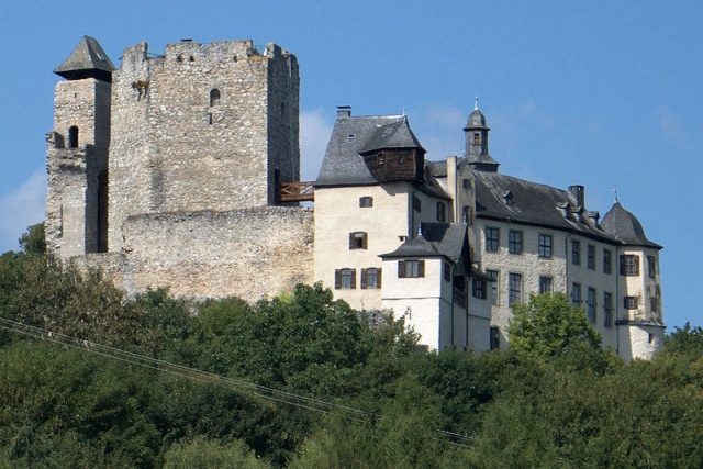
Hohlenfels Castle is a rock castle in the municipality of Mudershausen in the Rhein-Lahn district in Rhineland-Palatinate. It is privately owned, inhabited, and occasionally hosts special events.
The hilltop castle is located between Hahnstätten and Mudershausen in the Mudershausen district on a 231 m above sea level limestone rock, riddled with numerous fissures and cracks ("hollow"), above the Hohlenfelsbach valley. The rock drops steeply on three sides and rises up to 60 meters. To the fourth, southwestern side, the Fossenhelde (Fuchsenhalde) forest area adjoins.
In 1326, the later castle rock, along with some surrounding land, fell to Count Gerlach I from the Walramian line of the House of Nassau. He initially had a manor farm built below the present castle, from which the village of Hohlenfels later developed.
Before 1353, construction of Hohlenfels Castle was begun by Daniel von Langenau († 1389) on behalf of Count Johann I of Nassau-Weilburg-Saarbrücken († 1371). The castle was probably intended to control the trade route between Aachen and Nuremberg (Kemel-Limburger Straße) and the Hessenstraße, which passed in the immediate vicinity. The castle construction triggered a feud with the Counts of Diez, who saw their fortification sovereignty violated and were granted justice in a first arbitration award in 1353. This linked the construction of Hohlenfels with that of Neu-Elkerhausen Castle, with which allies of the Diez in turn threatened Nassau-Weilburg; possibly the construction of Hohlenfels Castle was intended as a response to this action. After the completion of Hohlenfels, an agreement was finally reached in 1363 to leave the castle itself as a Nassau fief, but to grant the Diez counts the right of access to Hohlenfels. The surrounding castle peace district and the milling rights were then granted to Lord Daniel von Langenau as a fief of the Counts of Diez.
After the death of Daniel's son Hildeger von Langenau in 1412, both fiefs were initially divided among the husbands of his two daughters, and subsequently further divided several times among their descendants and relatives, so that Hohenfels Castle represented a classic Ganerbenburg (jointly inherited castle) in the mid-15th century. Its joint administration was regulated from 1464 by a comprehensive castle peace treaty of all parties involved, which continued to grant both the Nassau-Saarbrücken and the Diez counts the right of access. From 1464, a chapel on the castle is also documented.
In the course of the 16th century, numerous shares of the castle fiefs gradually fell to the Lords of Mudersbach through joint inheritance and pledging, who eventually gained sole possession of the castle. After the death of Daniel von Mudersbach in 1600, the Counts of Nassau-Saarbrücken enfeoffed his son-in-law Hartmut von Kronberg († 1608) with Hohlenfels Castle and village in 1604.
During the Thirty Years' War, Hohlenfels was temporarily abandoned and partially destroyed. While the village, with the exception of the manor farm, became a wasteland, Johann Nikolaus von Kronberg († 1704) reoccupied the castle in 1685. After his childless death, the Nassau fief fell to his relative Hugo Friedrich Waldecker von Kempt († 1753), who had the main building of the castle, which is still habitable today, rebuilt from 1712 to 1716.
In 1753, the castle fief reverted to the Princes of Nassau-Usingen and was no longer re-granted, but placed under the Nassau office of Burgschwalbach and the supervision of the bailiff of Kirberg. Already in 1768, parts of the old wooden constructions were demolished; in the following period, large parts of the castle continued to decay. In the course of Rhine Romanticism, the already largely ruinous castle served several times as a motif for painters and draftsmen.
Occupied several times by the French during the Napoleonic Wars in 1802 and 1807/08, the castle, which housed a forest ranger's office from 1800 to 1885, and the manor farm at the foot of the castle rock, which had been expanded in the meantime, fell to Prussia as a state domain in 1866. In 1885, a restaurant and guesthouse operation was opened at Hohlenfels Castle, which existed until 1955 and, from 1901, could also be reached via Hohlenfels station of the Nassauische Kleinbahn, located in the immediate vicinity of the castle, and was served by passenger trains from Nastätten until 1953.
With the dissolution of Prussia in 1947, the castle and manor farm came into the possession of the state of Rhineland-Palatinate. After the end of the catering business in 1955, the castle stood empty until 1963; until 1978, it was then the seat of the Nerother Wandervogel (a youth movement). Since 1978, the castle has been privately owned again.
Due to its poor structural condition, the listed complex was classified as endangered in the late 1970s and closed to the public. At Easter 1979, parts of the almost 20-meter-high shield wall and the eastern zwinger tower collapsed. Subsequently, extensive safety measures were carried out, which also included stabilizing the fissured rock ("hollow rock"). Since summer 2005, after further renovation work, the castle has been accessible to the public again on a few days during the summer half-year.
Since 1973, a youth meeting center ("Domäne Hohlenfels") has been housed in the former manor farm at the foot of the castle rock.
Layout+
Of the extensive polygonal medieval fortifications and residential buildings, only the pentagonal keep and parts of the shield wall and the palas, designed as a residential tower, remain, on which renovation and restoration measures are still taking place. The new building from the 18th century, however, has now been completely renovated.
The fortress plateau was secured to the southwest by a twelve-meter-deep neck ditch, while on the other sides the steeply sloping rock served as security. Access was provided by a driveway leading to a gate in the southwest of the ditch, and a narrower path to the southeast side of the ditch. A total of six gates secured the castle courtyard. Access to the core of the complex was also secured by zwinger systems, from which the gates could be fired upon; the zwinger themselves were open to fire from the rest of the complex. Except in the northeast and northwest, the castle was protected by another, advanced zwinger. The originally almost 20-meter-high shield wall was comparatively thin at two meters thick and had a battlement and two small towers on the sides.
The keep, with its side length of up to 9.5 meters, is a particularly large example. It is 23 meters high and additionally stands on a rock block that rises five meters above the surroundings. The entrance, located at a height of eleven meters, could probably be reached via a wooden walkway from the top floor of the adjacent residential tower. A second access at 13 meters height was subsequently bricked up. The current ground-level entrance was opened later. Four defensive oriels were attached to the tower, which were removed in 1768.
Northwest of the keep rises a four-story residential tower (with cellar). Its floor plan is square with a side length of about seven meters. The uppermost room, used as a chapel, was created after 1753 by the insertion of an intermediate ceiling.
In the late Middle Ages, a more modern residential building was added to the western part of the curtain wall. Today, only the outer walls of the three-story building remain. A third residential building, into which a late medieval round tower was incorporated, was built from 1712 to 1716. The building with Baroque stylistic features is located on the northeast side of the entire complex.
An underground cistern was located on the east side of the castle courtyard.
Take Mobile History with you
You are reading this text for free. Premium adds what matters on the road: descriptions read aloud, sites found through your camera, whole regions taken offline.
- Every description, including the ~17,700 Premium sites
- Audio guide: have descriptions read to you on location
- AR finder: see sites through your camera, with distance and bearing
- Unlimited saved sites
14 days free, then from €2.99 a month. Cancel anytime.
Source: Wikipedia · Licence: CC BY-SA 4.0 · Image: http://de.wikipedia.org/wiki/Datei:Burg-Hohlenfels-JR-G6-3645-2009-08-04.jpg
This description draws on the facts documented in the linked Wikipedia article; Wikipedia content is licensed under CC BY-SA 4.0. Wording and editing: Mobile History.
Location: 50.2904, 8.0310