The Fortress can be visited
FortressUlm
Federal Fortress Ulm-Fort Örlinger Turm
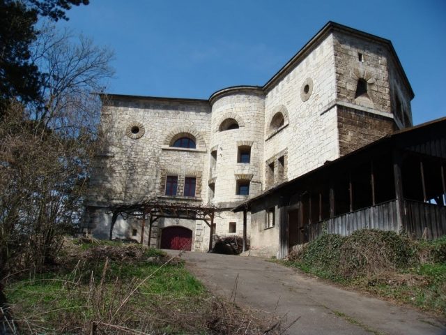
The fortress of Ulm (Bundesfestung Ulm) was one of five federal fortresses of the German Confederation around the cities of Ulm and Neu-Ulm. With its 9 km polygonal main circumvallation Ulm had the biggest fortress in Germany in the 19th century and it's still one of the biggest in Europe.
After the final defeat of Napoleon in 1815 the victorious powers agreed to defend the states from the inside. The fortresses were one of the few realised projects of the confederation. The fortress Ulm was planned by the Prussian construction manager Moritz Karl Ernst von Prittwitz und Gaffron and built under his supervision between 1842 and 1859.
In peacetimes the fortress should hold 5,000 men of the federal army, in wartimes up to 20,000 soldiers. A plan to expand the fortress to hold 100,000 men was never realised. The building costs were valued at 16,5 mio. guilders.
The fortress is a closed, polygonal wall system around the cities of Ulm in the Kingdom of Württemberg and Neu-Ulm in the Kingdom of Bavaria. In some distance detached works were added. The at this time first stone bridge across the Danube laid between both cities inside of the fortress. The next stone bridge was in Regensburg.
For the first time the bastion system was given up and replaced by a polygonal system with detached works, which is called Neupreußische Manier (New Prussian Fortress System) or Neudeutsche Manier (New German Fortress System). The later constructed works at the upper Eselsberg were built as so-called "Biehler-Forts".
Take Mobile History with you
You are reading this text for free. Premium adds what matters on the road: descriptions read aloud, sites found through your camera, whole regions taken offline.
- Every description, including the ~17,700 Premium sites
- Audio guide: have descriptions read to you on location
- AR finder: see sites through your camera, with distance and bearing
- Unlimited saved sites
14 days free, then from €2.99 a month. Cancel anytime.
Source: Wikipedia · Licence: CC BY-SA 4.0
This description draws on the facts documented in the linked Wikipedia article; Wikipedia content is licensed under CC BY-SA 4.0. Wording and editing: Mobile History.
Location: 48.4174, 9.9928