Cultural Events
The fortification can be visited
FortressJülich
Brückenkopf Jülich
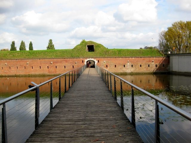
The Brückenkopf (bridgehead) in Jülich, Rhineland, is a fortress from the Napoleonic era, built at the beginning of the 19th century to protect the city from the west. It was integrated into the overall works of the Jülich fortress.
Construction Description+
The Brückenkopf is designed as a crownwork and has a width of about 800 meters, a depth of about 300 meters, and a height of about ten meters. It essentially consists of earth supported by walls. On the rampart are barrel-vaulted hollow traverses for the placement of cannons and for defense with small arms; they also serve for sectional defense should an enemy have conquered a section of the rampart. To the west, the width of the Brückenkopf is structured by two half-bastions and one full bastion. In contrast to the bastions of the citadel and the city fortifications from the 16th century, which are all full bastions (completely filled with earth), the bastions of the crownwork are empty bastions, which have no filling. The unofficial names of the bastions are:
- Zoo Bastion, also Bastion No. I
Northern half-bastion, named after the Brückenkopf Zoo, which is located around it. Referred to by the French as the right bastion.
- Middle Bastion, also Bastion No. II
Central full bastion, where a carriage house for artillery once stood. A Y-shaped cavalier was planned here but was never built.
- Bauhof Bastion, also Bastion No. III
Southern half-bastion, named after the Municipal Building Yard (Städtischer Bauhof), which had its home in its vaults after the Second World War. Due to its proximity to the heights around Aldenhoven, which offer a favorable attack position, this bastion is much more heavily designed than the other two and is equipped with a high cavalier. Referred to by the French as the left bastion.
In front of the escarpe of the Brückenkopf lies a wide, water-filled moat. Behind the escarpe is a continuous gallery with numerous embrasures for infantry defense. The structure was fronted by several moats and an extensive glacis.
The Brückenkopf protected the strategically important crossing over the Rur river. Since the Jülich fortress, with its extensive outer works, was also intended to serve as a standing camp for a field army, the protection of the bridge was of particular importance: not only should the enemy be denied its use, but it should also be available to its own troops. The lock bridge, newly built by the French, could dam the river course with its built-in lock gates and flood the entire area south of the fortress and around the Brückenkopf (inundation) to make it difficult for an attacker to approach. On the city side, there were some light fortifications in the form of a 1.25 m thick and 2.5 m high wall with loopholes to prevent circumvention at low water. The walls facing the Rur, whose foundations are still preserved and are now indicated by a hedge, are designed in a bastioned form to avoid blind spots.
The only freestanding building on the grounds of the "Bauhofbastion" is a gunpowder magazine built in 1806, similar to the one on Bastion St. Salvator of the Jülich Citadel. Both magazines are almost identical in their plan, but the one in the citadel is considerably larger. Like its larger brother, the building is one of the first structures in the city built using the metric system and consists of a heavy barrel vault with light, pre-faced side walls, which were designed to collapse in the event of an internal explosion, thus protecting the vault from destruction.
The Brückenkopf is of great architectural and art-historical significance, as it is the only preserved example of French Empire fortress construction technology from the early 19th century in Germany.
Late Antiquity to the 17th Century
The Rur crossing had been of strategic importance since Roman times and was a reason for the city's emergence. Already in late antiquity, the Romans built a castellum here to protect the river crossing and the road station in Jülich. With the emergence of the Jülich fortress in the 16th century, the protection of the Rur bridge also became more important, as it represented the only way to approach the fortress from the west. At the same time, it remained an important road structure on the way from France and Belgium to the Rhine. Already in the 17th century, depictions of the city show small fortifications at the head of the Rur bridge, which probably also played a role during the sieges of Jülich, but proved to be short-lived; presumably, they were simple earthworks.
French Period
Only the French, who marched into Jülich in 1794, placed greater emphasis on protecting the Rur crossing. They planned a major expansion of the fortress, which was to serve as an important staging fortress between the Rhine border and the French mainland, and the protection of the river crossing and the road was, of course, crucial. Furthermore, the fortified place was to serve as a base for a mobile army, whereby control of the river crossing was extremely important – it allowed their own troops to quickly move from one side of the river to the other and denied this capability to the enemy. In 1799, work began on the new Brückenkopf; the Lutheran church located at this site had to make way for the new construction. Shortly before the planned completion, Emperor Napoleon visited the construction site in 1804 and found the work not particularly successful – it was oversized and also vulnerable due to its proximity to the heights towards Aldenhoven. A smaller Brückenkopf combined with a fort on the questionable hill would have served the purpose better, but it was too late for a redesign due to the considerably advanced construction. They limited themselves to reinforcing the south bastion (today's Bauhofbastion) by means of an elevated upper rampart. A corresponding expansion of the other two bastions was also planned but was omitted for cost reasons. In 1808, the new fortress work was completed.
The Brückenkopf experienced its only test during the siege of Jülich in 1814, but there were only sporadic skirmishes, and the work remained unconquered. The Allies limited themselves to blockading the fortress to hold the garrison there and built their own bridge further south across the river. The Brückenkopf was thus simply bypassed, and the city's garrison was far too weak to attempt a sally. The Prussians took over the Brückenkopf when the city fell to them in 1815 and maintained it until the defortification of Jülich in 1860.
After the French Occupation
Afterwards, the complex was left to itself and used for other purposes. During the Franco-Prussian War, a prisoner-of-war camp was located here, and in 1893, a military swimming pool was established in the moat in front of today's Zoo Bastion. In 1911, the old country road, which had led south around the Brückenkopf, was replaced by a new road that passed through the fortress work, requiring part of the curtain wall to be removed. In 1929, the Brückenkopf was converted into a public park, and already in 1934, following Ludwig Moshamer's plans, it was rebuilt into a National Socialist Thingstätte, some parts of which have been preserved, such as the foundations of the former stage between the Middle and Zoo Bastions up to the surface of the moat. A Rhenish company used the extensive casemates for mushroom cultivation.
In World War II, the Brückenkopf was the scene of fierce fighting between German and American units in late 1944 and early 1945 and was severely damaged in the process. During the war, valuable holdings of the Jülich City Archives and Local History Museum were stored in a vault of the Brückenkopf; precisely this vault was destroyed by an unfortunate direct bomb hit, and with it the documents and artifacts. After the end of hostilities, the extensive casemates served as shelters for refugees.
Post-War Period and Current Use
In the post-war period, the fortifications fell into disrepair and were overgrown by trees and undergrowth. The parade ground inside was used as a fairground and as the location for a riding hall, and the machinery of the Municipal Building Yard found its place in the south bastion. A guesthouse also settled along the road, which was finally demolished in 2006. From the 1970s onwards, parts of the ramparts served as enclosures for the Brückenkopf Zoo, and from the 1980s onwards, initial restoration work began.
After severe war damage and decades of decay, the site was integrated into the State Garden Show in 1998, and about 90% of the Brückenkopf was restored. The interior and the glacis were transformed into a large park with extensive garden facilities. So far, only the faces of the Middle Bastion remain unrestored. Today, the Brückenkopfpark Jülich serves as a local recreation area and event venue. In 2005, the fortress park was included in the Road of Garden Art between the Rhine and Meuse as an outstanding example.
Take Mobile History with you
You are reading this text for free. Premium adds what matters on the road: descriptions read aloud, sites found through your camera, whole regions taken offline.
- Every description, including the ~17,700 Premium sites
- Audio guide: have descriptions read to you on location
- AR finder: see sites through your camera, with distance and bearing
- Unlimited saved sites
14 days free, then from €2.99 a month. Cancel anytime.
Source: Wikipedia · Licence: CC BY-SA 4.0 · Image: http://de.wikipedia.org/wiki/Datei:Brueckenkopf01-DaB..jpg
This description draws on the facts documented in the linked Wikipedia article; Wikipedia content is licensed under CC BY-SA 4.0. Wording and editing: Mobile History.
Location: 50.9208, 6.3502