To be privately owned
ManorDuisburg - Huckingen
Sandmühle Manor
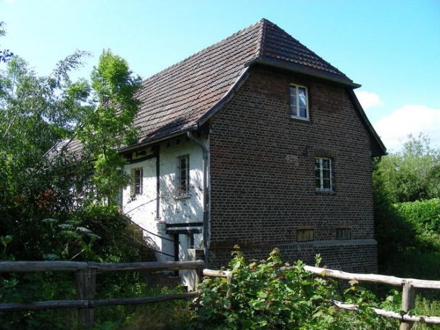
The Sandmühle is a historic mill complex in the southeast of the Duisburg district of Huckingen, located on Düsseldorfer Landstraße and the old Angerbach stream.
Origin of the Name+
The name "sant moelen" of the former, water-powered grain mill derives from its geographical location. The building was erected on the old Angerbach stream at an offshoot of the Heidberg, a sand dune in the Rhine glacial valley.
Owners and Tenants+
The first documented mention dates back to 1448. In a 16th-century copy of the document, Knight Hermann von Winkelhausen's ownership rights to the Sandmühle are confirmed by his sovereign Gerhard, Duke of Jülich and Berg and Count of Ravensberg. The document further states that these rights had already been "given to Hermann's parents and ancestors." In 1551, Hermann von Winkelhausen transferred the mill as a dowry to his nephew Johann. In 1884, Prince Alfred von Hatzfeld-Wildenburg acquired the Sandmühle estate, which at that time included more than 15 hectares of land in the municipalities of Huckingen, Mündelheim, and Wittlaer. After the Lambertusstift Düsseldorf was temporarily the owner, the Sandmühle fell to the Count von Spee in 1927, who in turn sold the Sandmühle to the city of Duisburg in 1955.
The Sandmühle was leased out until the 20th century. It is striking that the mill remained in the hands of the same families for generations. The oldest known lease agreement dates from 1685. In it, the Sandmühle is leased to Theißen Siepenkotten and his wife Metschen Brockhauß. Other tenants included Heinrich Siepenkotten (1773–1783), his son Johannes (1783–1792), then again Heinrich Siepenkotten, as well as his grandson Heinrich Bors and his descendants until the beginning of the 19th century. After that, the Sandmühle passed to a Holzschneider family, until 1910 to the Schmitz family (Mrs. Schmitz was born Holzschneider), from 1910–1931 to the Bloemenkamp family (Mrs. Bloemenkamp was born Schmitz), and from 1931–1956 to Michael Kreifels, a son of the neighbor from the Kesselberg estate.
Archaeological Findings+
Today, the mill complex consists of the mill building, which has been extended and altered multiple times over the centuries, as well as two other freestanding buildings presumably from the 19th century: a brick barn located to the northwest and another brick building to the southwest.
Archaeological investigations have shown that the mill building was constructed in at least 6 phases. A medieval predecessor building, a stone hall building, is estimated by experts to date from the 12th–13th century. Evidence of this includes rubble stone foundations, approximately 1.20 m thick and about 1.80 m deep, within the current mill building. Based on this, the core of the current mill building was erected around 1687. A northern extension presumably occurred in the 18th century, a western extension between 1800 and 1805, which was further extended in 1906. In 1913, the building was expanded on the east side.
The building type and its location between Angerbach, Bruchgraben, and a moat visible on a map from 1817 suggest a medieval noble residence in the form of a moated castle. It is presumed that the Kesselsberg estate, located on the other side of the Anger, served as an economic farm for the noble residence Sandmühle. When exactly the noble residence Sandmühle became a watermill is not known. However, it is evident that the Angerbach, which originally flowed somewhat further east, was diverted to the mill building for use by the watermill.
The archaeological findings further confirm that in the second half of the 17th century, presumably with the lease to Theißen Siepenkotten in 1685, the noble residence, which had fallen into disrepair, was extensively renovated and expanded. For stabilization, an old millstone was placed under the dilapidated foundation, a new half-timbered building, largely still standing today, was erected on the old rubble stone foundations, and presumably a second waterwheel was also installed at this time.
Usage+
The Sandmühle was a grain mill throughout its entire period of use. It should be noted that until the 19th century, the construction and operation of a mill was a sovereign privilege. This was associated with a milling obligation that applied to all estates and farms within the milling district. For the Sandmühle, this compulsory area included the localities of Huckingen, Serm, Mündelheim, Ehingen, and Rheinheim.
Until 1913, the mill was driven by waterwheels. These were then replaced by a turbine due to higher efficiency. At the same time, the eastern extension of the mill building was carried out. After the Angerbach was straightened and relocated to the west side of Huckingen in 1927, thus drying up the old Angerbach bed, the mill had to be operated electrically. In 1956, mill operations ceased and the last miller left the Sandmühle. The residential area of the mill building remained inhabited until the 1980s.
Even then, there were considerations to renovate the Sandmühle, as the building showed considerable defects. Moisture in walls and floors, as well as corresponding dry rot infestation, were the main problems. Between 1990 and 1992, the upcoming renovation was prepared. The building was surveyed, existing constructions and building materials were recorded, and damages and weak points were identified. After it was decided that the use should remain unchanged, i.e., a residential area in the western extension from the beginning of the 19th century and the mill rooms in the core of the building without permanent use, the actual renovation was carried out between 1992 and 1995.
Today, the Sandmühle is a structural and archaeological monument of the city of Duisburg. The western extension of the mill building is now inhabited again. The two brick buildings are used commercially.
Take Mobile History with you
You are reading this text for free. Premium adds what matters on the road: descriptions read aloud, sites found through your camera, whole regions taken offline.
- Every description, including the ~17,700 Premium sites
- Audio guide: have descriptions read to you on location
- AR finder: see sites through your camera, with distance and bearing
- Unlimited saved sites
14 days free, then from €2.99 a month. Cancel anytime.
Location: 51.3550, 6.7448